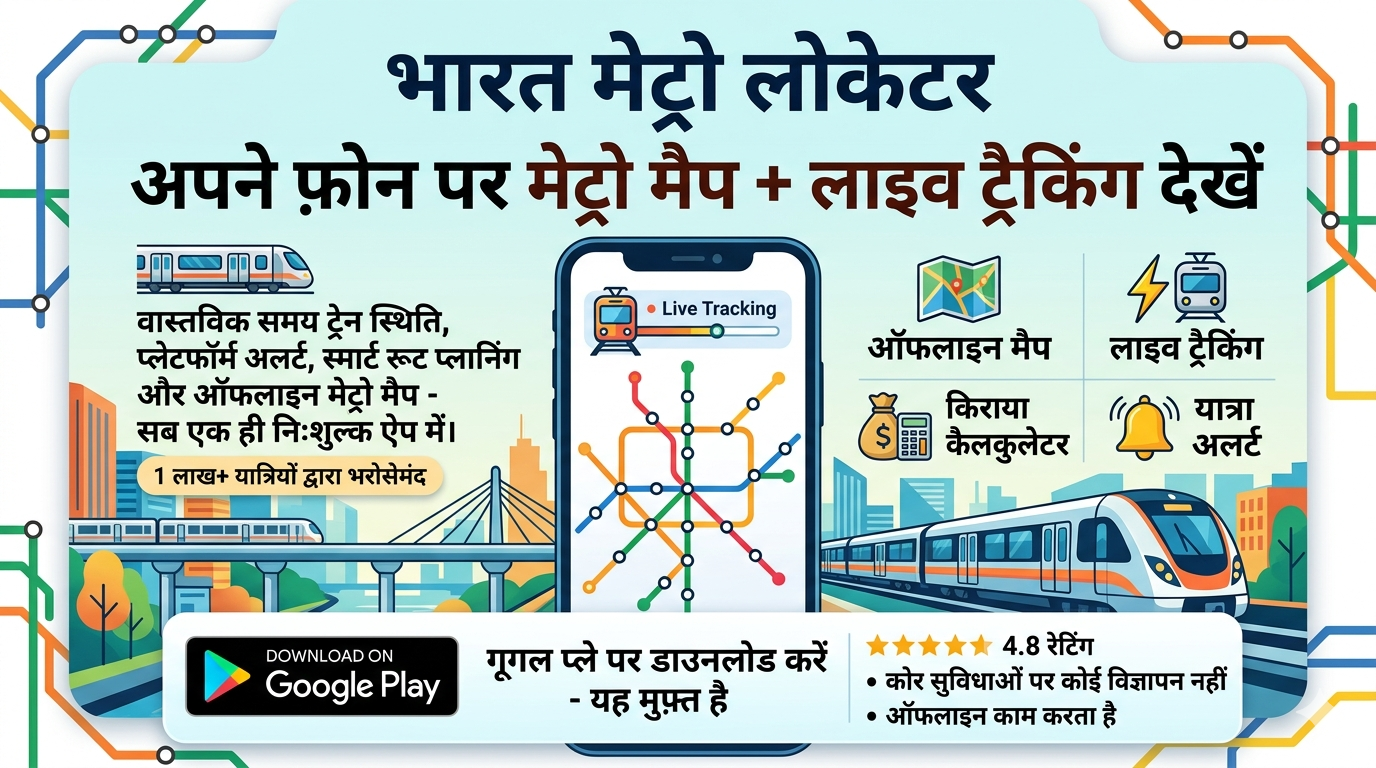
Why trust our Delhi Metro map?
Bharat Metro Locator pulls data directly from DMRC’s GTFS feed and crowdsourced rider reports. That means every interchange, first/last-train timing and fare slab you see here is refreshed nightly (and often sooner after major service updates).
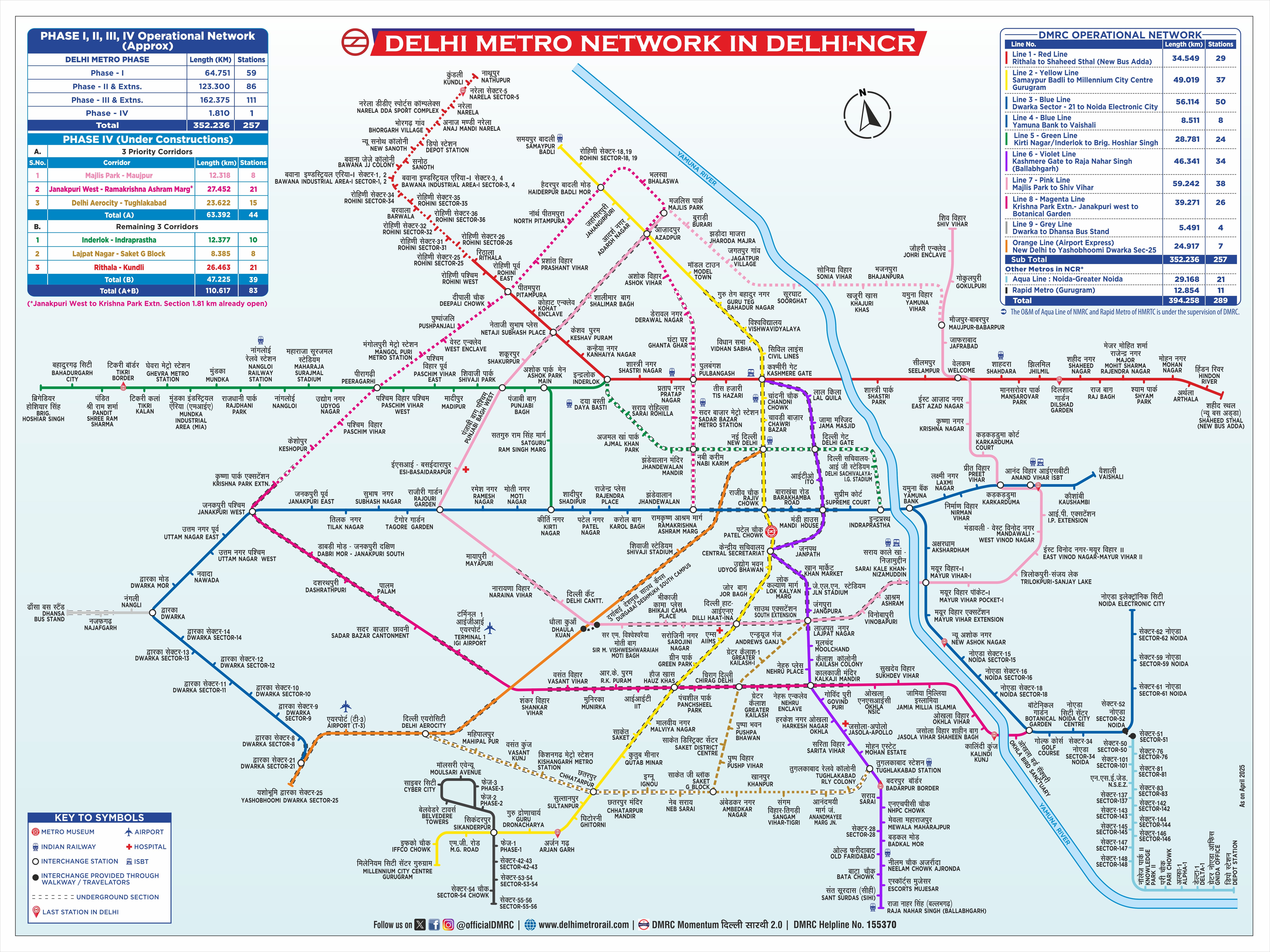
Comprehensive coverage of all lines (2025)
From the heritage-rich Yellow Line connecting Samaypur Badli to HUDA City Centre, to the new Magenta & Pink lines that create orbital links around South & North Delhi, our interactive layer lets you tap any station to reveal platform numbers, first/last trains and exit-gate information.
Smart route planner
Enter source & destination and our algorithm returns multiple options ranked by total travel time, number of interchanges and walking distance. A single click pins the path on the map & displays a Delhi Metro route and fare breakdown.
Fare calculator & travel cards
We factor in peak/off-peak slabs, Smart Card discounts and the NCMC where applicable, so you always know the exact Delhi Metro price before you board.
Delhi Metro at a glance (2025)
- Total route length: 390 km across 12 colour-coded corridors
- Daily ridership: ~5.1 million passengers (April 2025 average)
- Airport Express travel time: 19 min (New Delhi ⇄ IGI T3)
- Fastest escalator: Hauz Khas interchange, 15.6 m vertical rise
Upcoming extensions
Phase IV construction is underway, adding 65 km of new tracks—including priority corridors from Janakpuri West to R.K. Ashram and Aerocity to Tughlakabad—slated for completion by late 2026. Bookmark this page; we’ll update the New Delhi Metro Map the moment new stations open.
Popular Metro Routes
Rajiv Chowk to New Delhi Railway Station
Distance: 2.5 km | Time: 5 min | Line: Yellow Line
Plan your Delhi Metro route with our smart route planner for the best travel options.
Kashmere Gate to Red Fort
Distance: 2.0 km | Time: 4 min | Line: Violet Line
Plan your Delhi Metro route with our smart route planner for the best travel options.
Central Secretariat to India Gate
Distance: 1.5 km | Time: 3 min | Line: Yellow Line
Plan your Delhi Metro route with our smart route planner for the best travel options.
Hauz Khas to Qutub Minar
Distance: 3.0 km | Time: 6 min | Line: Yellow Line
Plan your Delhi Metro route with our smart route planner for the best travel options.
Real-Time Updates
As of 01:22 PM IST on Saturday, July 26, 2025, all lines are operating normally. Check the Delhi Metro app for live Delhi Metro timings or service changes.
User Reviews
"The metro from Rajiv Chowk to New Delhi Railway Station is super convenient, though it gets crowded during rush hours!" - Ankit S.
"Loved the quick trip from Kashmere Gate to Red Fort. The Delhi Metro app made it so easy!" - Priya M.
Exploring Delhi Metro: Routes, Fares, and Map Downloads
The Delhi Metro is a lifeline for millions, offering an efficient way to navigate the city. Whether you're looking for the latest Delhi Metro Map PDF or the Delhi Metro Map download in Hindi, our platform provides all the tools you need. The New Delhi Metro Map 2025 covers 390 km across 12 lines, with popular routes like Chhatarpur to IIT Delhi taking just 13 minutes. Check the Delhi Metro route and fare details to plan your journey, and use the Delhi Metro app for real-time Delhi Metro timings and ticket purchases. Download the Delhi Metro Map PDF today for offline access!