

San Francisco Bay Area · BART & Muni Metro

San Francisco Bay Area Yellow-N Subway Map

Millbrae/SF Int'l SFO to Antioch: complete stations, route order, line colour, transfers and official transit links.

28stations#FFFF33line colour
About this line page

Station order and coordinates come from the configured Bay Area Rapid Transit and San Francisco Municipal Transportation Agency transit feed. Check the operator’s live service notice before travelling because planned work and skipped stops can change.

Open official map and service source →

Route map image

Millbrae/SF Int'l SFO to Antioch station map and route

Downloadable map image generated from the imported station order. Open the official operator source for live service changes and current alerts.

San Francisco Bay Area Yellow-N subway map with station names
San Francisco Bay Area Yellow-N line station map · official operator map and service source

BART & Muni Metro Yellow-N line official map

Official agency map

28 stations in route data
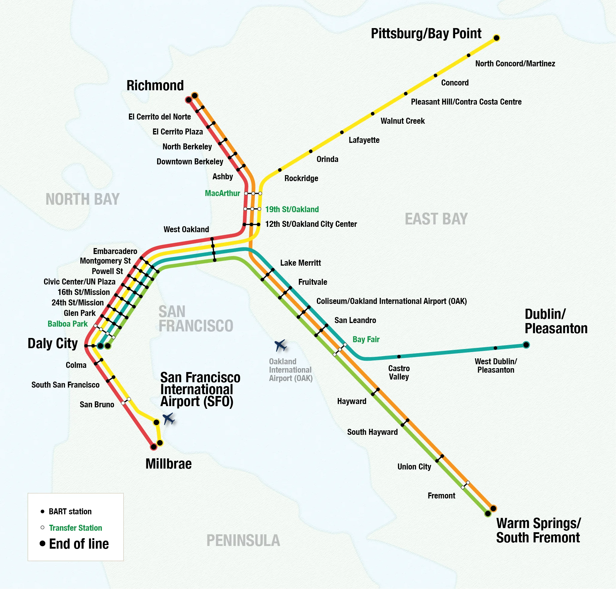
BART & Muni Metro Yellow-N line official transit map

Click map or use +/− to zoom · scroll to zoom · drag when zoomed

Official network map / PDF

Source: BART & Muni Metro Yellow-N line transit agency. Route and station details remain data-driven below.

Complete station list

Yellow-N line stations

28 stops
1. Millbrae#FF0000 · View station details →2. San Francisco International Airport#FF0000 · View station details →3. San Bruno#FF0000 · View station details →4. South San Francisco#FF0000 · View station details →5. Colma#FF0000 · View station details →6. Daly City#0099CC · View station details →7. Balboa Park#0099CC · View station details →8. Glen Park#0099CC · View station details →9. 24th Street / Mission#0099CC · View station details →10. 16th Street / Mission#0099CC · View station details →11. Civic Center / UN Plaza#0099CC · View station details →12. Powell Street#0099CC · View station details →13. Montgomery Street#0099CC · View station details →14. Embarcadero#0099CC · View station details →15. West Oakland#0099CC · View station details →16. 12th Street / Oakland City Center#FF0000 · View station details →17. 19th Street Oakland#FF0000 · View station details →18. MacArthur#FF0000 · View station details →19. Rockridge#FFFF33 · View station details →20. Orinda#FFFF33 · View station details →21. Lafayette#FFFF33 · View station details →22. Walnut Creek#FFFF33 · View station details →23. Pleasant Hill / Contra Costa Centre#FFFF33 · View station details →24. Concord#FFFF33 · View station details →25. North Concord / Martinez#FFFF33 · View station details →26. Pittsburg / Bay Point#FFFF33 · View station details →27. Pittsburg Center#FFFF33 · View station details →28. Antioch#FFFF33 · View station details →

Plan your trip

Yellow-N train route, transfers and map

Use the network route planner to choose a source and destination. For current delays, skipped stops or planned maintenance, use the official operator link above rather than relying on a saved map.