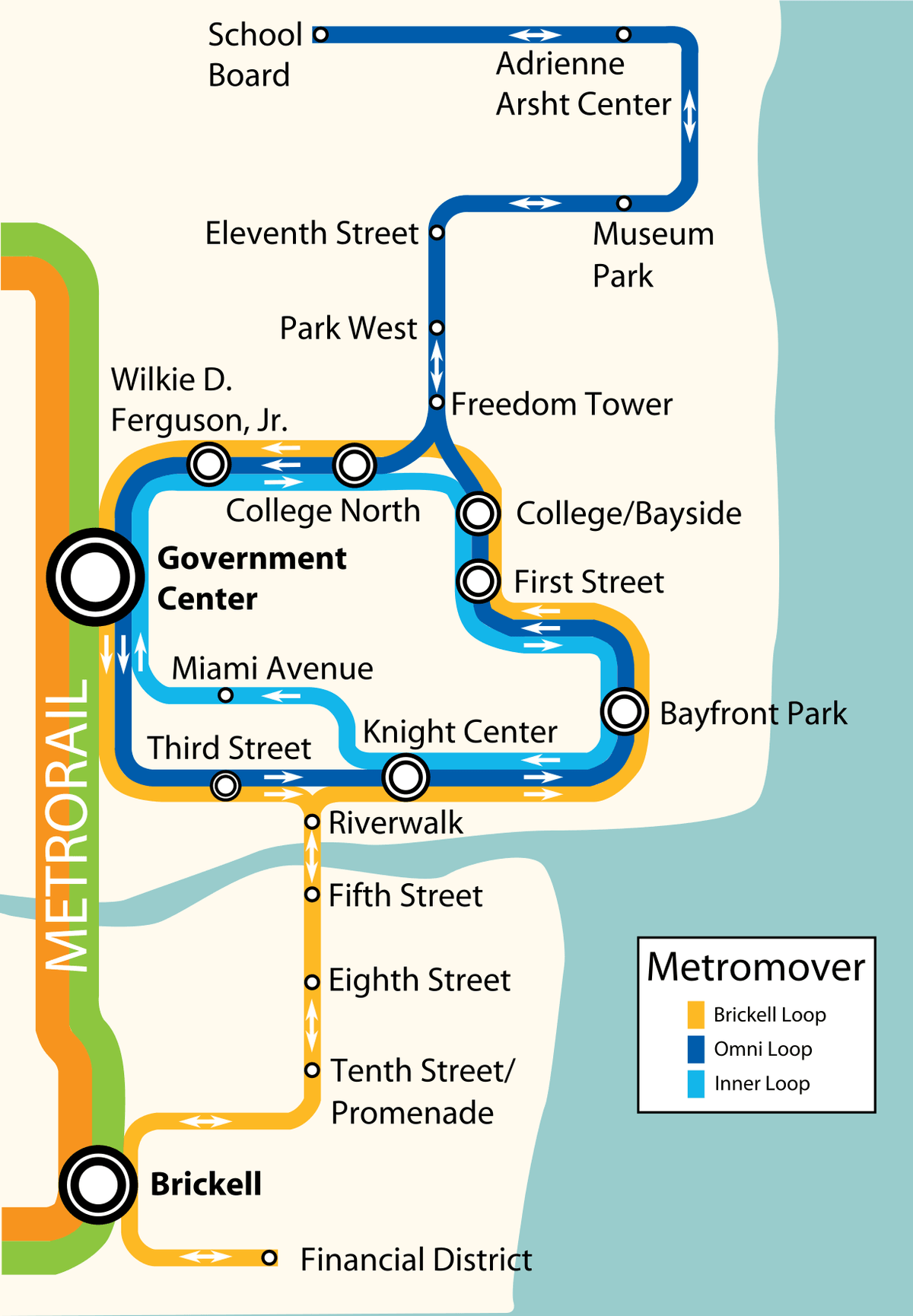
1. Adrienne Arsht CenterOmni Loop · Inner Loop · Brickell Loop · Check official map for loop and connection details
2. School BoardOmni Loop · Inner Loop · Brickell Loop · Check official map for loop and connection details
3. Eleventh StreetOmni Loop · Inner Loop · Brickell Loop · Check official map for loop and connection details
4. Museum ParkOmni Loop · Inner Loop · Brickell Loop · Check official map for loop and connection details
5. Miami WorldcenterOmni Loop · Inner Loop · Brickell Loop · Check official map for loop and connection details
6. Freedom TowerOmni Loop · Inner Loop · Brickell Loop · Check official map for loop and connection details
7. College NorthOmni Loop · Inner Loop · Brickell Loop · Check official map for loop and connection details
8. Wilkie D. Ferguson, Jr.Omni Loop · Inner Loop · Brickell Loop · Check official map for loop and connection details
9. Government CenterOmni Loop · Inner Loop · Brickell Loop · Check official map for loop and connection details
10. College BaysideOmni Loop · Inner Loop · Brickell Loop · Check official map for loop and connection details
11. First StreetOmni Loop · Inner Loop · Brickell Loop · Check official map for loop and connection details
12. Knight CenterOmni Loop · Inner Loop · Brickell Loop · Check official map for loop and connection details
13. Bayfront ParkOmni Loop · Inner Loop · Brickell Loop · Check official map for loop and connection details
14. Third StreetOmni Loop · Inner Loop · Brickell Loop · Check official map for loop and connection details
15. RiverwalkOmni Loop · Inner Loop · Brickell Loop · Check official map for loop and connection details
16. Fifth StreetOmni Loop · Inner Loop · Brickell Loop · Check official map for loop and connection details
17. Brickell City Centre (Eighth Street)Omni Loop · Inner Loop · Brickell Loop · Check official map for loop and connection details
18. Tenth Street PromenadeOmni Loop · Inner Loop · Brickell Loop · Check official map for loop and connection details
19. BrickellOmni Loop · Inner Loop · Brickell Loop · Check official map for loop and connection details
20. Financial DistrictOmni Loop · Inner Loop · Brickell Loop · Check official map for loop and connection details
21. Miami AvenueOmni Loop · Inner Loop · Brickell Loop · Check official map for loop and connection details